- 1. Research on Theory of Brain-inspired Intelligence Model for Spatio-temporal Big Data
|
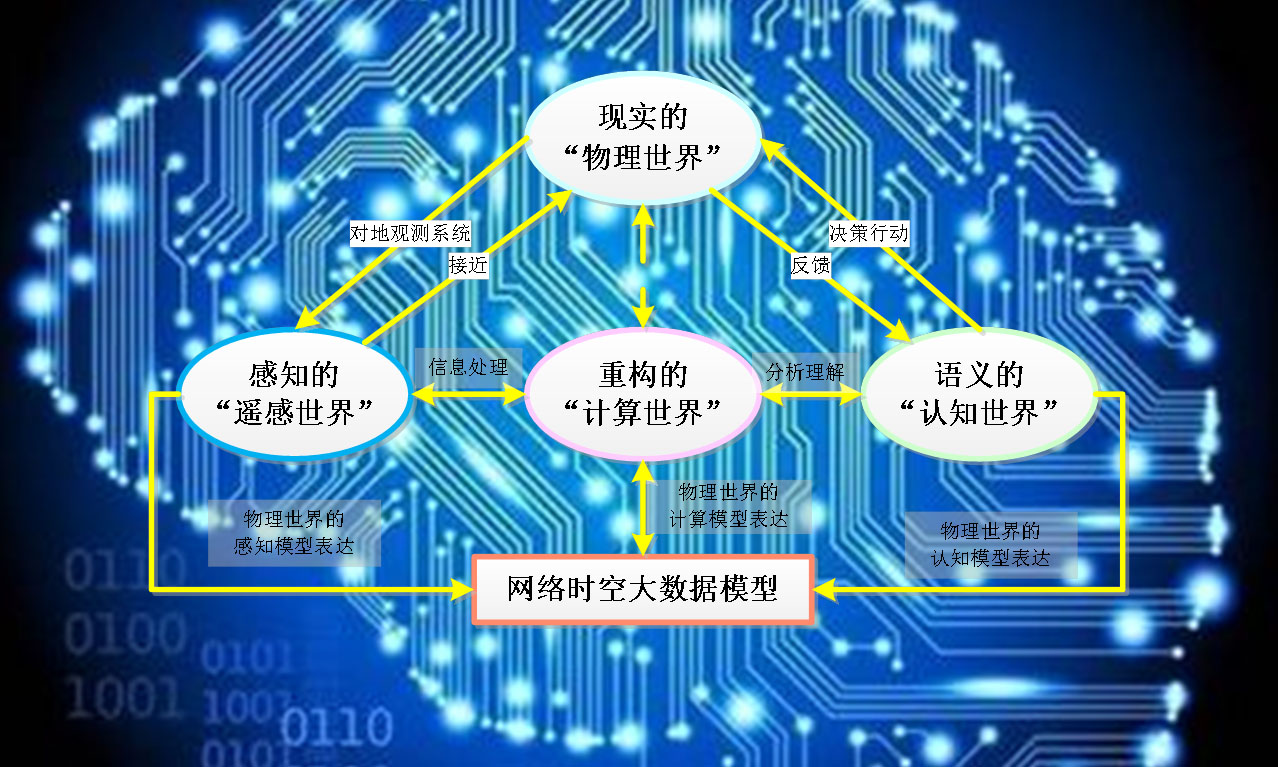
| Aiming at the core theoretical issues of Spatio-Temporal Information Processing (STIP), this research focuses on the Brain-Inspired Intelligence (BII) model of Spatio-Temporal Big Data (STBD), cross-media brain-like perception computing model, human-computer hybrid BII model, BII model of group cooperative system, BII and cooperative decision-making of autonomous system, and scientific theories related to STIP such as brain-inspired machine learning. This research directions includes: |
|
(1) Mulitimedia Neural Cognitive Computing (MNCC) Theory
(2) Cross-modal Brain-inspired Computing Model
(3) BII Model for STIP
(4) Research on Knowledge Graph Theory of Remote Sensing Application
(1)Research Group of BII
(2)Research Group of Intelligent STIP
|

|
- 2. Research on the Key Technology of Intelligent Information Extraction Algorithms for Remote Sensing
|
| Using the BII model of STBD, the intelligent extraction algorithm of remote sensing Spatial-Temporal Information (STI) would be explored and designed. This research focuses on exploring how to use brain-inspired computing methods such as deep learning, cognitive computing and reinforcement learning to solve the core algorithms of intelligence information extraction, such as saliency computing, perceptual feature processing, hierarchical incremental memory, and emotional reinforcement learning of remote sensing STI. This research directions includes: |
(1) Research on Target Classification and Recognition Algorithms
(2) Research on Parallel Computing Processing Algorithms for STBD
(3) Research on Knowledge and Visualization Algorithms in Remote Sensing Applications
(4) Remote Sensing Information Sharing and Active Service Technology
(5) Research on Intelligent Algorithms of High Precision Land Use Classification
(1)Remote Sensing Intelligent Information Extraction Technology Group
(2)Target Classification and Recognition Technology Group
(3)High Precision Intelligent Land Use Classification Technology Group
|

|
- 3. Engineering Application Research and Development of Remote Sensing High Performance Computing Platform
|
| Based on the background of urban remote sensing information extraction and industry application of Unmanned Autonomous System (UAS), the high-performance production process of remote sensing information products would be developed. Parallel computing technologies such as multi-core heterogeneous and high-performance server cluster would been developed. Computing resources, data resources and computing tasks are reasonably scheduled to achieve high-performance processing of remote sensing Target Classification and Recognition (TCR). Various remote sensing information products acquired or produced by high performance computing platform based on remote sensing STBD provide multi-dimensional information on agriculture, land, city and transportation for government departments at different levels of provinces, cities, counties and townships, so that management departments can timely grasp the dynamic information of land resources utilization and urban development. This work includes: |
(1) Research on Software Architecture of Remote Sensing Information System
(2) Research and Development of High-efficiency Information Processing Platform for Remote Sensing STBD
(3) Research and development of Remote Sensing Product Integration and Sharing System
(4) Research and development of Digital Earth
(5) Research on Cloud Computing and Service Platform of UAS
(6) Research on Intelligent Embedded Platform for UAS
(1) Remote Sensing Data Processing System Development Team
(2) Remote Sensing Data Sharing and Service Development Team
(3) High Efficiency Information Processing Development Team for Remote Sensing STBD
(4) Digital Earth Development Team
|

|
|
Henan Province Engineering Research Center of Spatial Information Processing, Kaifeng 475004, China
Address: Jin Ming Avenue, Kaifeng, Henan, China
Zip Code: 475004
Email:Sea@vip.henu.edu.cn
Telephone :0371-23883088
|
|